The United Nations(UN) General Assembly has approved a resolution encouraging the wider use of world map projections that represent the relative size of Africa and other land masses more accurately.
The resolution, spearheaded by Togo and backed by African states, was adopted on Friday with 164 countries voting in favour. Six countries abstained, while the United States was the only country to vote against the measure.
The resolution promotes the Equal Earth projection, an equal-area map designed to provide a more accurate representation of the relative sizes of continents than the widely used Mercator projection.
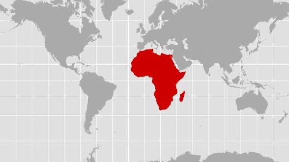
The Mercator projection was developed in the 16th century for navigation. Although it remains useful for preserving directions, it makes land areas farther from the equator appear disproportionately large.

The distortion is particularly noticeable when comparing Africa with regions such as Greenland. Africa is vastly larger in actual land area, but the two can appear similar in size on a Mercator world map.
The Equal Earth projection was developed to preserve the relative areas of continents while presenting their shapes in a recognisable form. It therefore provides a different visual representation of the world’s land masses.
Togo has led the campaign for greater use of more accurate world maps, building on efforts supported by the African Union. The initiative argues that commonly used maps can influence people’s understanding of the relative size and importance of different regions.
READ RELATED NEWS
NELFUND board member to Atiku: Tinubu did not order tuition fee hike
African airlines record cargo growth despite shrinking capacity — IATA reports
Togo’s Foreign Minister Robert Dussey has promoted the campaign as part of a broader effort to challenge longstanding perceptions of Africa and encourage a fairer representation of the continent.
The issue has attracted attention because maps are widely used in schools, news organisations, government institutions and digital platforms. Supporters believe that using area-accurate projections in such settings could improve geographical understanding and give students a more realistic picture of the world.
However, the General Assembly’s decision does not constitute a worldwide ban on the Mercator projection. The resolution is not legally binding and instead encourages governments, educational institutions and other organisations to consider more accurate projections for appropriate uses.
Mercator maps are also expected to remain useful for navigation because of their ability to represent directions effectively. The resolution therefore seeks to encourage greater use of alternatives such as Equal Earth rather than eliminate every existing Mercator map.
Togo plans to introduce the Equal Earth projection into its school geography materials by the end of the year and to encourage wider international adoption, including by organisations and technology companies involved in mapping services.
The UN’s decision is consequently less about changing geographical boundaries than about changing how the world’s geography is visually presented.
For African campaigners and supporters of the initiative, the resolution represents an important symbolic step towards ensuring that maps used in education, media and technology provide a more accurate picture of Africa’s enormous geographical scale.
The decision is likely to fuel further discussion about the relationship between cartography, education and perceptions of the world, particularly the way different map projections can shape people’s understanding of Africa and other regions.